
Another concern is that we had no real idea about the conditions of the trails. Friends in CO said that there was still a fair amount of snow, and although the trails out west are less rocky than in my side of the country, the lack of experience in that area meant we didn't really know what to expect.
From reading online trail reports and calling a ranger station, we learned that the loops we were considering still had heavy snow fall, leaving some passes almost impassable. Certain parts of the trail were blown out from avalanche debris or completely covered in snow. Many stream crossings were difficult to cross due to broken logs or sketchy snow bridges, etc.
Originally, we had thought about doing the Capital Creek Circuit, which is about 40 miles and far less traveled than the Four Pass Loop (4PL), but because it is less trafficked, there were less trail condition reports, and attempting 40 miles when we didn't know how we'd handle the elevation was probably not smart.
Given the information we collected, we opted to hike the Four Pass Loop, covering 26.6 miles in three days, two nights.
Day one -


Tips to know: You can only drive to the overnight parking at the Maroon Bells Welcome Station before 8:00 am or after 5:00 PM, otherwise you need to park at the Aspen Highlands Village parking lot, pay per night (which is about $25 a day), and take the shuttle (pay per person) into the welcome station. If you drive in early enough, you only pay $10.
Rather than beginning the loop the day after arriving, we spent our second day in Colorado hiking up to Buckskin Pass and back, giving us additional time to acclimate. We stayed in Snowmass Village that night to make our drive to the trailhead shorter. Not having to wake up at 3:00 am? Sweet!
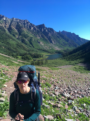
By the time we got to the parking lot, pulled out our packs and self-registered, we got started at about 7:00 am. The hike to Crater Lake is about 1.8 miles of a slow uphill. The starting elevation is around 9580 feet, and the passes are over 12,000 feet, so we had a lot of ground to cover.
When we got to Crater Lake, we briefly stopped to snap a few pictures and drink some water. I began having altitude headaches the night before, so I wanted to keep on top of my hydration. Some dumb woman asked me to move, as I was in the frame of her picture. Despite arriving to Crater Lake before 8:00 am, she didn't seem to have the time to wait a few seconds for her precious picture taken by her precious DSLR. Have a great day!
People can be the worst and the best part about being in nature.

Further down West Maroon Trail, we discovered that sections of the trail are entirely submerged in water. My boots are fully gusseted, so I could carefully step through deeper sections without worrying about soaking my boot. Except for further down the trail when I lost my footing and stepped into water, soaking my right boot. It eventually dried out.


The second obstacle was this massive snow bridge over West Maroon Creek. The snow seemed pretty solid further away from the exposed portion, but you never really know just how deep or solid the snow is, so it's best to walk as quickly as possible.
I saw two women approach the other side just as we finished crossing. I never saw them again, so I don't know if they turned around or eventually crossed.

This is somewhere further down West Maroon Trail, but before the pass. We basically kept hiking, stopped to filter water and eat some food, and continued hiking. The scenery was so beautiful.


Ominous clouds began rolling in as we neared West Maroon Pass, elevation 12,480. We put on crampons when the pass became steeper, moving as quickly as we could. Some people run this loop in a day, and they probably just use spikes. Not knowing what to expect, we came over-prepared. At the top, a rain/snow mix started and we heard thunder and saw some lightning, so as quickly as we could, we descended the other side of the pass.

Once we descended the other side of the pass, the time was around 1-2 PM. I forget. The rain kept coming and we weren't sure we wanted to go over another pass that day. According to the map, we saw this campsite that had a bit of shelter from the rain and wind, so we made a beeline for it to scout out a tent spot.

Once the rain stopped, we finished setting up the tent and I went to a tiny stream to collect water for dinner and the next morning.

We had a pleasant evening cooking dinner and relaxing before we called it a night. I, once again, did not get up in the middle of the night to see the stars.